A NEW archaeological map confirms that Angkor in Cambodia was the biggest pre-industrial city ever founded and provides tantalising clues about its mysterious demise 500 years ago.
Sprawling about 1000sqkm out from its central religious heart with its legendary temples and reservoirs, known as Angkor Wat and Angkor Thom, the vast city was roughly the size of Singapore, or greater Sydney from the coast to Parramatta.
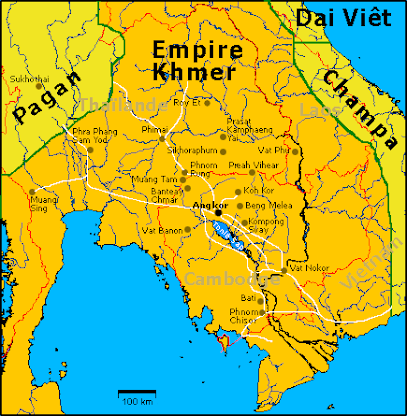
Angkor itself was the capital of a sparsely settled agricultural empire that stretched from Thailand in the north, across the flood plains, and southwards towards the Cambodia-Vietnam border.
"Like the modern world there was a vast expansion of the urban environment out into the rural world," said Sydney University archeologist Roland Fletcher, founder and co-director of the Australian, French and Cambodian Greater Angkor Project.
A goal of the project was to nail down the geographical extent of the city. According to GAP deputy director Damian Evans, a Sydney University doctoral student, the new map does just that.
"This is the culmination of about 15 years of mapping work," said Mr Evans, who led the effort to integrate the data into the map, revealed overnight in the US journal Proceedings of the National Academy of Sciences.
Sources included hand-drawn maps, ground surveys and airborne photography provided by GAP members and ground-sensing radar images provided by the US space agency NASA.
Not only does the map reveal the extent of Angkor -- a Khmer kingdom from the 9th to the 15th centuries -- it pinpoints over 1000 new water storage ponds and more than 74 long-lost temples. In its heyday, as many as 500,000 people may have lived in the sprawling low-density city. The map will allow scientists to tighten population estimates.
According to Mr Evans, the map also provides hard evidence backing the controversial hydraulic hypothesis.
This states that Angkor was linked by a vast network of irrigation channels, storage ponds and reservoirs. As the city grew, land was cleared, causing soil to clog the channels. Eventually, it became too expensive and complicated to keep the system free-flowing and it collapsed, taking Angkor with it.
The city, in essence, engineered its own demise by disrupting the environment.
"We can certainly see there were problems in the hydraulic networks," said Mr Evans.
"There's evidence of water courses punching through dykes and inadequate attention (to maintenance)."
Said Professor Fletcher: "It's a cautionary tale for the modern world."

Monday, August 13, 2007
Sprawling Angkor engineered its own end
Subscribe to:
Post Comments (Atom)


No comments:
Post a Comment